News
Site Editor
 Site
https://mide-act.usa72.wondercdn.com/uploads/image/635cdcc32f0fa.png
Whether the vehicles are guided autonomously, or guided by ground-based pilots, GPS in UAV plays an important role. As long as sufficient satellite signals can be accessed during the entire UAV mission, GPS navigation techniques can offer consistent accuracy. Often, GPS is used in conjunction with Inertial Navigation Systems (INS), to offer more comprehensive UAV navigation solutions.
Site
https://mide-act.usa72.wondercdn.com/uploads/image/635cdcc32f0fa.png
Whether the vehicles are guided autonomously, or guided by ground-based pilots, GPS in UAV plays an important role. As long as sufficient satellite signals can be accessed during the entire UAV mission, GPS navigation techniques can offer consistent accuracy. Often, GPS is used in conjunction with Inertial Navigation Systems (INS), to offer more comprehensive UAV navigation solutions.
How Is GPS/GNSS Used in UAV?
Views: 518
Author: Site Editor
Publish Time: 2023-02-09
Origin: Site
Unmanned Aerial Vehicles (UAV) are increasingly being used for a wide range of applications including reconnaissance, surveillance, surveying and mapping, spatial information acquisition and geophysics exploration, among others. Often, in these situations, GPS is the key to operating the UAV safely.
Whether the vehicles are guided autonomously, or guided by ground-based pilots, GPS in UAV plays an important role. As long as sufficient satellite signals can be accessed during the entire UAV mission, GPS navigation techniques can offer consistent accuracy. Often, GPS is used in conjunction with Inertial Navigation Systems (INS), to offer more comprehensive UAV navigation solutions.
The most common use of GPS in UAV is navigation. A central component of most navigation systems on a UAV, GPS is used to determine the position of the vehicle. The relative positioning and speed of the vehicle are also usually determined by the UAV GPS. The position provided by the receiver can be used to track the UAV, or, in combination with an automated guidance system, steer the UAV.
Autonomous UAV usually rely on a GPS position signal which, combined with inertial measurement unit (IMU) data, provides highly precise information that can be implemented for control purposes. In order to avoid accidents in an area heavily populated by other UAV or manned vehicles, it is necessary to know exactly where the UAV is located at all times. Equipped with GPS, a UAV can not only provide location and altitude information, but necessary vertical and horizontal protection levels.
As stated above, UAV are often used for earth observation measurements, making use of cameras and radars installed for this very purpose. In order to accurately geographically reference collected data, it is important to know the exact position of the vehicle when a measurement or photo was taken. A UAV GPS receiver can pinpoint the exact position of the UAV, often down to the centimeter. The same concept applies to the exact time at which the photo or measurement was taken. The precise time stamps provided by UAV GPS are invaluable in collecting this information.
Purchase Mide MH4N12A spiral antenna from us
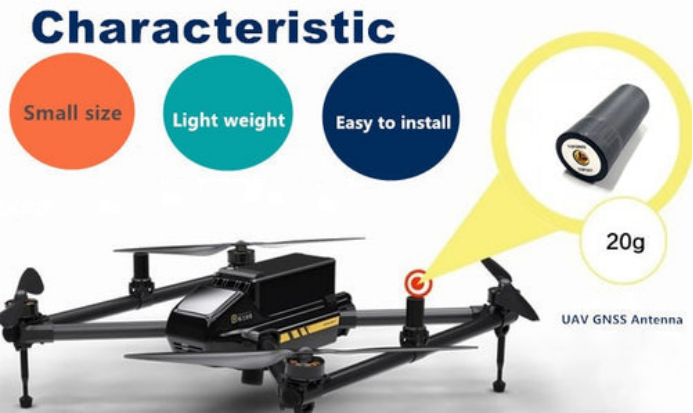
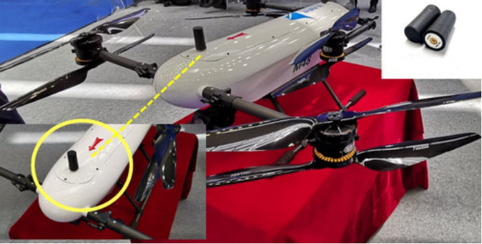
MH4N12A is a four-star full-frequency spiral antenna, which has the characteristics of small size, high positioning accuracy and lightweight. High-precision positioning supports signal reception of GPS, BDS, GLONASS, GALILEO and satellite-based augmentation systems, providing multi-system multi-directional strong satellite signals to provide centimeter-level positioning accuracy, while effectively dealing with interference between systems in the UAV's long-distance multi-band working environment, so that the UAV always maintains directional fixation during the automatic flight, providing high safety, to ensure the reliability and controllability of the UAV in the work. Mide, a professional UAV antenna system manufacturer, has a wealth of UAV GPS antenna solutions. Let us discuss the UAV antenna tracking control system and make the world a better place.