A choke ring antenna is an omnidirectional antenna designed for high frequencies (VHF & UHF). It consists of concentric conductive cylinders surrounding a central antenna. To protect it from the elements, the choke ring antenna is often enclosed in a radome or protective cover when installed outdoors.
The choke ring antenna is a high-performance GNSS antenna used for base stations, capable of tracking GPS, GLONASS, BeiDou, BeiDou Global, and Galileo systems. Its design meets the requirements for high precision and multi-system compatibility in measurement equipment. This antenna offers a stable phase center and high positioning accuracy for GPS applications. Additionally, the GNSS choke ring antenna includes specially designed filters that reduce multi-path signals in the L1 and L2 bands.
The choke ring antenna provides stable phase-center, offering accuracy at the millimeter level. Its choke ring structure effectively mitigates multipath interference and enables the tracking of low-elevation satellites. The antenna's radome is resistant to water, ice, snow, and dirt, allowing it to operate outdoors throughout the year.
Choke ring antennas are particularly notable for their ability to reject multipath signals, making them ideal for GPS and radar applications. In GPS ground-based receivers, choke ring antennas can provide precise measurements at the millimeter level, which is valuable for surveying and geological measurements.
Application
The 3D choke ring antenna, equipped with multi-path suppression technology, effectively eliminates signal transmission errors. It also exhibits excellent anti-interference performance, suppressing unnecessary electromagnetic signals and preventing blockage from power grids, communication base stations, and radio stations. With its low elevation angle, high gain, good signal reception, and stable phase center, the choke ring antenna ensures sub-millimeter positioning accuracy. Currently, choke ring antennas are widely used in high-precision surveying and mapping, CORS stations, bridge and building deformation monitoring, and geological monitoring due to their sub-millimeter phase center stability.
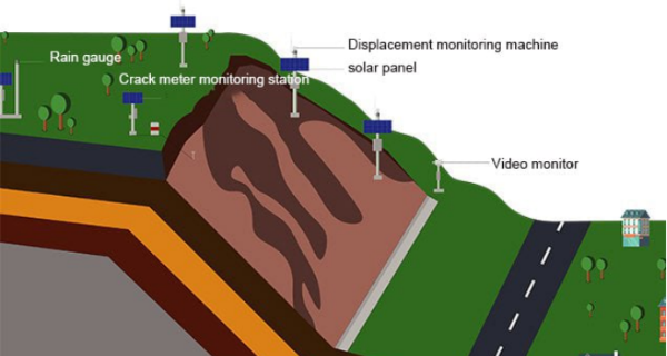
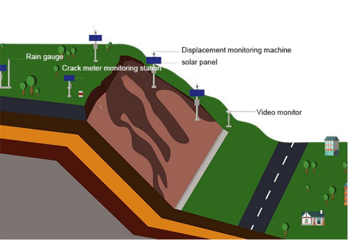
Automated Monitoring Solutions for Geological Hazards
The automated monitoring solution for geological hazards leverages global satellite navigation satellite positioning (GNSS) technology, sensing technology, the Internet of Things, and cloud computing to provide real-time monitoring of deformation, stress and strain, disaster environment, mud level changes, rainfall, and other indicators. This integrated system collects, transmits, and displays data, offering a comprehensive monitoring solution that enables real-time collection, transmission, and warning of geological disaster monitoring indicators.
Solution for Safety Monitoring of Water Conservancy Dams
The water conservancy dam safety monitoring system utilizes real-time perception of various environmental, deformation, displacement, structure, stress, and seepage parameters to calculate and analyze the overall stability of the dam. It provides timely and accurate alarms for potential hazards, allowing long-term control and scientific data support for safety management. The system facilitates automatic collection, transmission, storage, analysis, and early warning of monitoring data, supporting additional functions such as modifying/deleting data, software window alarms, email alarms, SMS alarms, and sound and light alarms.
Hydrological and Rainfall Monitoring Solution
The hydrological monitoring system enables remote real-time monitoring of water and rain conditions in rivers, reservoirs, artificial rivers, and waterways. It includes modules for user management, hydrological basic information management, GIS, automatic hydrological measurement and reporting, data query and management, data analysis, forecasting and early warning, etc. This system allows management departments to timely grasp the hydrological conditions of the river basin, such as precipitation and water levels, facilitating prompt management decisions.
Water Quality Monitoring Solutions
Online water quality monitoring plays a crucial role in water environment management. By utilizing unmanned ships with water quality monitoring instruments, the online water quality monitoring system can promptly detect abnormal changes in
water quality, provide rapid warning and prediction for water pollution prevention and control, track pollution sources in a timely manner, and effectively save manpower, financial resources, and time costs. Turbidity sensors and various water quality monitoring instruments can be configured according to project requirements. These instruments have the capability to obtain abnormal information records and upload data.
Solution for Slope Safety Monitoring Along Highways
The highway slope safety monitoring solution incorporates global satellite navigation satellite positioning (GNSS) technology, sensing technology, the Internet of Things, cloud computing, and other advanced technologies to monitor real-time conditions such as deformation, stress-strain, disaster-prone environment, mud level changes, and rainfall along highway slopes. This comprehensive monitoring solution enables the collection, transmission, and warning of highway slope safety monitoring indicators in real time.
Mine Safety Monitoring Solution
Online safety monitoring of mining engineering involves conducting real-time and systematic scientific analysis of changes in slope engineering morphology based on slope engineering monitoring data. This analysis aims to predict, avoid, and reduce unsafe factors on slopes, providing reliable data and a scientific basis for the correct analysis, evaluation, prediction, and treatment of unstable slope areas.
Solutions for Structural Health Monitoring of Bridges
To enhance bridge safety and health, control bridge damage, and eliminate safety hazards, this solution integrates advanced monitoring technology for bridge safety monitoring. It provides a targeted structural health online monitoring system for bridges, considering their different types, structures, and geographical locations. The system enables real-time collection, transmission, and warning of bridge monitoring indicators.
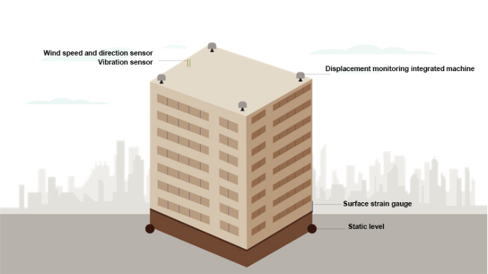
Solution for Structural Health Monitoring of High-Rise Buildings
The Structural Health Monitoring solution for high-rise buildings is a highly integrated system that incorporates monitoring sensors, intelligent acquisition units, communication systems, power supply systems, and more. It can operate in harsh environments for extended periods, offering low power consumption, strong stability, and easy installation. By monitoring various data, the system transmits information to a data collection management and monitoring warning cloud platform. This platform performs data analysis, storage, query, analysis, display, statistics, warning, reporting, and other functions.
Contact MIDE for Your Choke Ring Antennas
In conclusion, choke ring antennas have a wide range of applications and benefits for various industries. Whether you are working in aviation, navigation, or telecommunications, understanding the capabilities of choke ring antennas is crucial for improving performance and efficiency. If you're interested in learning more about choke ring antennas or have any questions, feel free to contact us. Our team of experts is always happy to assist you with your antenna needs.